• Skip to primary navigation
  • Skip to content
  • Skip to primary sidebar
  • Skip to footer

SkinTrack

  • Lightest Gear
    • Skis
    • Boots
    • Bindings
    • Skins
    • Packs
  • Skimo Training
    • Training Plans + Skimo Manual
    • Transitions Videos
  • Facebook
  • Instagram

Coast Mountains

John Baldwin Interview: Multi-Week Ski Traverses, Exploring Canada’s Coast Mountains, Creating Ski Maps and Guidebooks, Modern Navigation…

March 12, 2020 By Stano Faban Leave a Comment

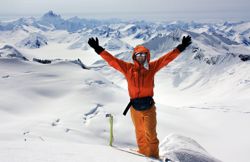
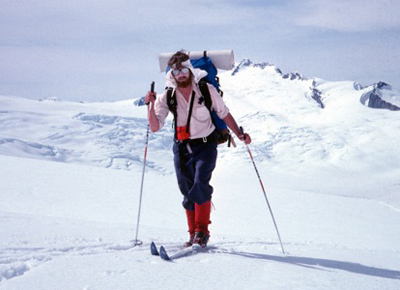
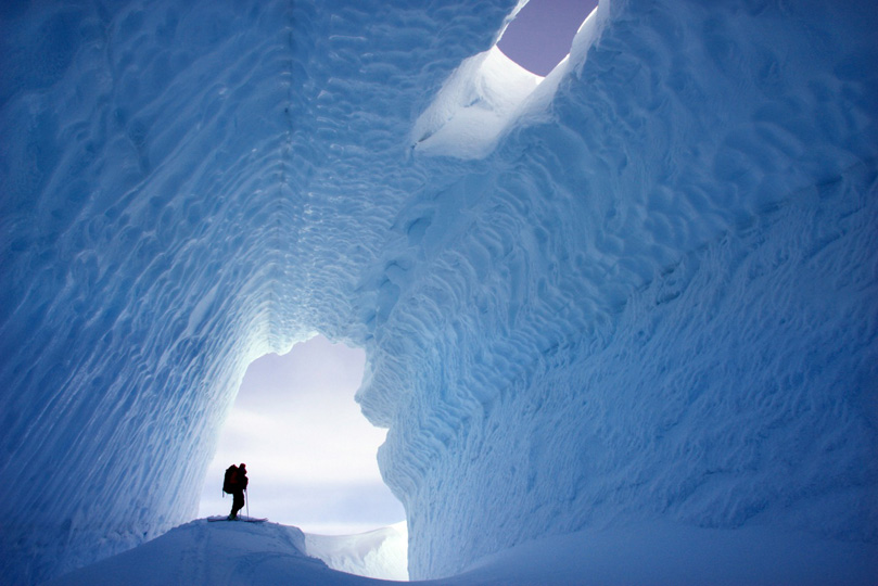
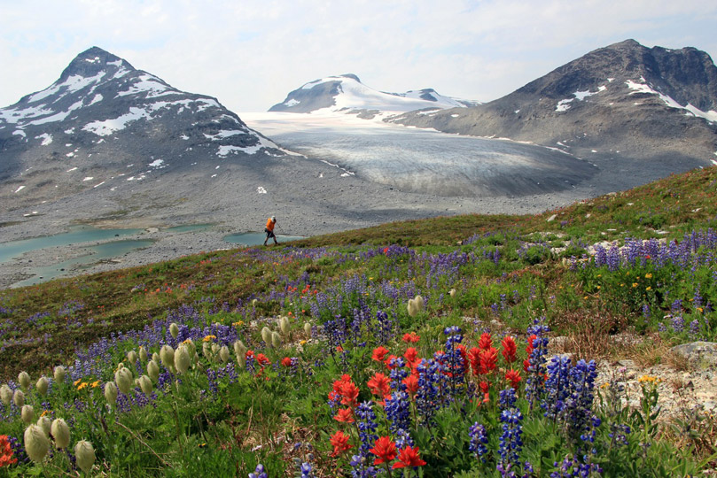
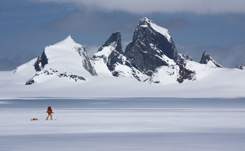
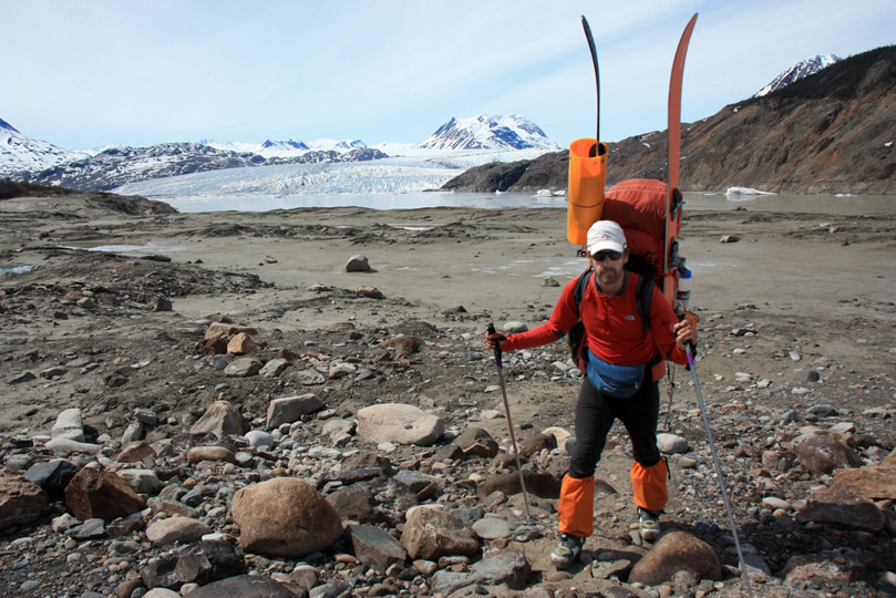
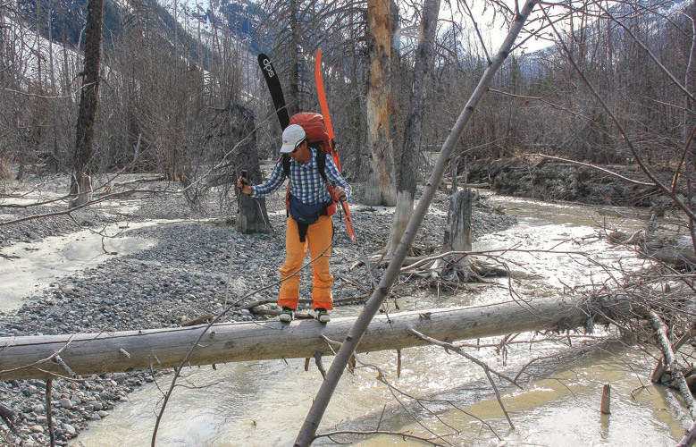
John Baldwin is arguably one of the greatest pure North American explorers. He has chosen to do most of his travels on skis and has authored several books and maps so others can experience the great Canadian wilderness with a bit of guidance.

Over the years, I have had the great pleasure of skiing and hiking with John Baldwin and Linda Bily, John’s wife, on several occasions and we always had plenty of fun.

John and Linda are probably best described by their own quote from their book Soul of Wilderness:

Ours are not heart-stopping tales of conquest and hardship…. The purpose of our trips is simply to see as many of these special places as we can.

Note: All images are copyrighted by John Baldwin and Linda Bily, and were used with their permission.

John Baldwin’s Guidebooks and Maps

John on one of his earlier ski traverses on Lillooet Icefield.

John has authored several books, including ski guide books and maps, that focus on his beloved Coast Mountains and western British Columbia.

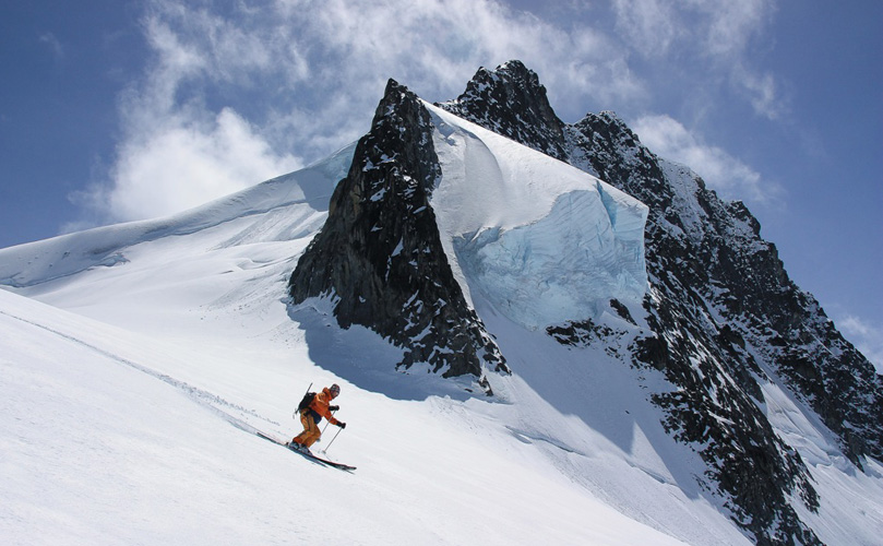
People’s most popular publication of his has been the Exploring the Coast Mountains on Skis that is a superb guide to ski mountaineering in the Coast Mountains of western British Columbia from the Washington border to the Alaska panhandle.

For a full list of John’s books, maps and online purchase visit his website JohnBaldwin.ca.

Interview with John Baldwin

Q: Whether it is a multi-week ski traverse or just a day trip, what is most important to have a remarkable mountain experience?

There is a term called forest bathing that has become more popular recently. I think this is a big component of ski touring – you might call it mountain bathing or snow bathing.

I think moving through the mountains on skis is a great way to connect with nature and the outdoors. I feel that a sense of wonder and gratitude for the mountains are part of this.

Q: I remember when we met for the first time… both of us skiing solo in the mountains above Vancouver. I was new to Canada but already studying your ski guidebook. You quickly became my inspiration for exploring. Who were the people that inspired you and in which ways?

There are many levels to answer that question…

There were the people that helped me to learn how to go into the mountains – my leaders in Scouts, my high school French Teacher Hans Fenz.

Then there are people who inspired me by their mountain activities – Don and Phyllis Munday, Dick Culbert and Glenn Woodsworth, John Clarke, Chic Scott, Galen Rowell. All of these people had an idea that grabbed them and they followed that idea with passion.

It’s good to be curious about life – that is something I learned from my father and it’s good to appreciate the beauty in life – that is something I learned from my mother.

The most important lesson is to follow your heart.

Q: You have created and published your books and maps with little outside help. You self-thought most of the skills you needed. Is this an obvious extension of your wilderness adventures? Do you like to be self-reliant in all aspects of life?

That is partly true, I like a hands on approach when I do things. I enjoy the learning and exposure to all kinds of things that comes from that. At the same time, I did rely on others with some of the technical aspects of publishing and using complicated mapping and graphic design software.

Also, when you are doing something for the first time – either in the mountains or writing for example – you have to follow your own vision because there is no else to follow.

Skiing over the wast Juneau Icefield that crosses the Canadian boarder with Alaska and extends 140 km north to south and 75 km east to west.

Q: You have dedicated your life to exploring Canadian Coast Mountains which line the west coast of British Columbia for hundreds if kilometres. What lured you specifically to them for so long?

The simple answer is that I grew up in Vancouver staring at the southern end of the Coast Mountains and became curious about what lay up there.

I fell in love with the magnificent land that lay hidden in the clouds. And it has taken most of my life to just get to some of their most amazing places.

I didn’t consciously ignore other places or activities, I just did what I wanted to do most at each step of the way.

John at a camp on Homathko Icefield with Mount Waddington, the highest mountain in British Columbia behind by LB

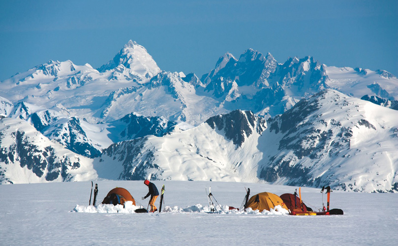
Q: During all your long remote expeditions, your groups have never had a major accident. How did you manage that? You survived a massive fall in your twenties, was that an early wake-up call?

Many of my trips were before satellite phones, and Spot or InReach devices. It was essential to plan each trip carefully.

The mountains are very powerful. It is important to be respectful and appreciate that when you are in them. Yes, I suppose in a way, falling off the mountain helped me appreciate that. One wrong step and you can fall 500m!

You don’t need to be afraid and fearful when you are in the mountains but you do need to be aware of what you are doing and where you are.

Q: You have an incredible sense for reading terrain and interpreting a map. Is this something you have always had, or it has naturally developed within you over the years?

I am an engineer and I have always been good at map reading and visualizing things in three dimensions. Staring at maps and using them to constantly navigate through new terrain has also helped immensely.

I think we also have an innate sense of terrain in all of us. We have been travelling over the earth for millions of years and we are meant to do that.

Q: Do you use Google Earth or other modern applications?
I use it a lot for inspiration and researching new ideas. Once outside, I prefer to read terrain and look at a paper map or phone map occasionally, mostly without compass or GPS. You could say, I am trying to be romantic about it…

Absolutely, Google Earth is amazing! To be able to see the landscape in such detail is incredible… But there are limitations – it often doesn’t show crevasses very well and like a map you still need experience to really be able to read the terrain well.

I strictly use Google Earth for planning and it’s fun to look at for new areas. It has also been invaluable for making my ski touring maps. I also use caltopo.com and hillmap.com, which are really useful online mapping tools that can translate from a map to a satellite image.

Q: Do you think that those who rely a lot on modern navigational tools – phone apps with GPS, or simply following a downloaded GPS track – are robing themselves of a more profound experience? Aren’t these modern tools making us a bit dumber perhaps?

There are no rules, use whatever works for you. I do agree with you that overusing modern navigational tools will not help you learn how to interpret terrain.

My advice is to always try and estimate where you are before you use a GPS and see how well you did. That way you will learn.

Most ski traverses in Canada start and end with long walks in the wild forests or valleys.

When GPS devices first came out I used to race a friend and his GPS to see who could estimate our location faster. I often would win (and back then when the GPS signals were weaker, I was often more accurate).

Ski routes are not hiking trails and their GPS tracks cannot be followed like a video game. You need to be constantly looking around and assessing avalanche conditions, crevasses, changing micro terrain, rocks etc.

With practice you should be able to look at a map in the morning and know where you are for most of the day and only need to refer to the map when there are very specific spots that you need to navigate through.

Q: I know that you prepare most of your expedition food at home. Do you use any sports bars or store freeze-dry food?

I sometimes use nutrition bars on day trips but I don’t like most of them.

For longer trips, I usually make up my own snacks. For meals, I will use some freeze dried ingredients but never freeze dried meals in a bag.

Q: How much food in weight do you bring per person on a week-long ski traverse? What is most important to you about the food you bring?

The old rule was about 900g (2lbs) per person per day.

It’s important to bring healthy nutritious food that you like. You can make your own simple meals that cook relatively quickly. I have never lost weight on any three week trip.

Backpacks for only even a week-long ski traverse easily weigh 20-25kg (50lbs) as one needs to carry, on top of the food, also a sleeping bag, pad, tent, cooking stove… For more technical traverses, add glacier and mountaineering gear, and soon you are at 30kg (65lbs).

Q: You have managed to organize your life to have plenty of time for adventuring. Despite living close to Vancouver’s downtown, you live simply. Have you ever thought about living in a small town?

First off, I grew up in Vancouver, so that is my home and that is a big part of why I live here. I also love living near the ocean – I feel it is like the base for the Coast Mountains.

I have thought about living in a small town but I was never able to find work there so it never happened. I also find that when I am in the city that I only live in a small part of it, and can ride my bike and do most errands locally so that it feels a lot like a small town.

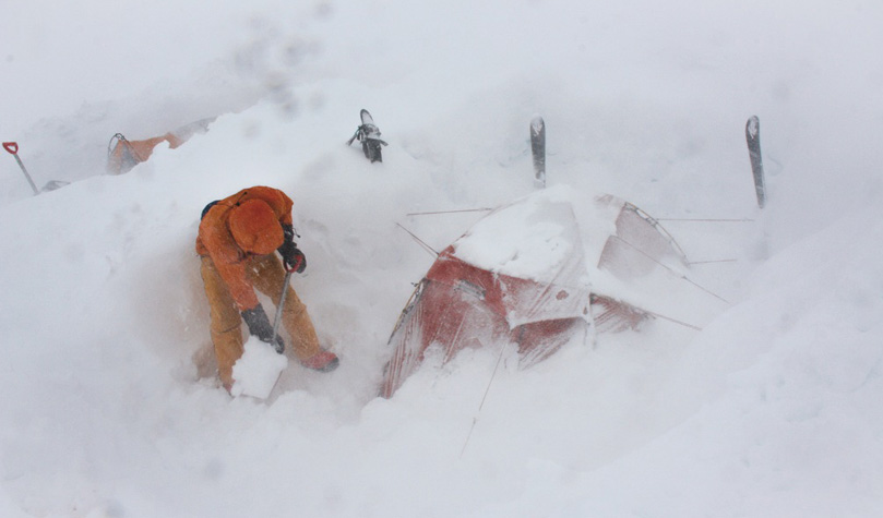
Q: When you are stuck on a big glacier in a storm, how do you spend the time? Do you read books?

People pay big money to go on meditation retreats. Just think of a storm day as a free retreat 🙂
It’s good for you to have time to just daydream and rest.

I often bring a book for storm days. I enjoy books about the true stories about people and parts of BC. I would trade books with others in the tent too.

John digging out the tent once again during 5 day storm on Juneau Icefield.

Q: What projects are currently occupying you? Any new trips or books in the plans?

In the summer, I was busy going through all my old photos for Chic Scott who wrote a biography about me for the Alpine Club of Canada Summit Series. The pdf is available free online or you can order a printed copy.

Now, I am reprinting some maps right now with some small updates. I am also doing another printing of my guidebook.

Then I am always planning trips and looking at maps and Google Earth. And I have been sewing a new ski touring day pack as I love making things.

Filed Under: People (Interviews) Tagged With: Coast Mountains, John Baldwin, ski traverse

North Joffre Creek mini-traverse: Spring skiing and bush whacking

August 29, 2009 By Stano Faban 1 Comment

This trip took place in Duffey Lake area in the southern part of Coast Mountains, Canada, during May 23-25, 2009. Duffey Lake backcountry skiing is a serious rival destination to the famed Rogers Pass near Revelstoke, BC.

A detailed description of the North Joffre Creek traverse can be found in John Baldwin’s book – Exploring the Coast Mountains On Skis.

Day 1 – bush whacking

Peter fighting some serious flora to get us started.

Since spring conditions are one of the best to explore new terrain, due to high snowpack stability, stable weather and long days, we decided to go out on for three days.

Two of us, Stano Faban and Peter Mrazik, headed up the Duffey Lake road on Saturday morning. We parked our car on a logging road (km 3) on the east side of the North Joffre Creek, since this was the spot where we would finish the trip.

The late date and warm days just before our trip prepared quite a bush whacking for us. Avoiding swaps, which are skied over in the winter, by crossing the creek and the valley higher up meant dry boots but very thick bushes. We couldn’t carry the skis on our packs since we weren’t able to move a step forward with such a setup.

Navigation is vital...as is a lunch break.
Finally, after two and a half hours (at about 1400m), we made it to some continuous flanks of snow. Once on skis, we moved through the old forest at a decent speed arriving at a lake east of Cassiope Peak for a late afternoon lunch.

From here we headed directly west towards a wide pass (more of a ridge) between Cassiope and Saxifrage Mountain. The lake was in melting conditions, so we opted to stay on its north side by climbing up about 50m higher onto some mellower terrain.

After reaching the wide pass we decided to go little further towards Saxifrage and pitch a tent there to be ready for some morning spring skiing.

Route to a pass east of Cassiope Peak, which is just out of the photo to the left.

Day 2 – ski time

Early morning plans were slightly disrupted by our vacation moods. However, this turned out to work in our favour as the east face of Saxifrage was in prime conditions at around 8.30am.

East of Saxifrage Mountain. We skied down slightly right from the center.
We boot-packed up to reach a ridge just right of the summit. From here it was a scramble for few meters and then a short boot-pack in the snow to reach the top. The view was amazing.

Skiing down the east face is getting steeper (around 40-45 degrees) but in those conditions it was perfect. This was a summit and a face that I was eying for some time since it looks quite attractive from Cayoosh Mountain where I go often. Cayoosh is just few valleys to the east from here.

After getting down we packed our gear and headed north through another fairly wide col immediately east of Saxifrage. From here, skiing down to White Lakes was great. Although, on couple of spots right off the top, the snow was bullet proof, it eased to spring corn very soon.

Once crossing the White Lakes we stopped and turned around. The valley looked spectacular and sure worthwhile to stick around for some skiing. We’ll come back in the future.

Our living room, on a shoulder of Cirque Peak, was waaay nicer than any waterfront condo.
After a long “lazy” lunch in a pass between Mount Olds and Mount Oleg we climbed up to the summit of Mt Oleg and skied back to grab our packs. Then we skied further down the Place Glacier to reach Joffre Glacier.

After good laughs and some more skinning we cooked our dinner on a shoulder that is south of Cirque Peak. We relaxed, talked, laughed and ate in an amazing calmness of the surrounding mountains with no society craziness in sight.

Joffre naming “controversy”

When reaching the Joffre Glacier we realized a funny fact. Joffre Lakes that are on the south side of the Duffey Lake road are fed water from Matier Glacier.

Being on the north side of the Duffey Lake road and standing on the Joffre Glacier we wondered how this geographical naming happened. From the map, it’s very clear that Joffre Lakes and Joffre Glacier have nothing to do with each other except their names. (If someone knows more please post a comment below.)

Day 3 – more great skiing

Since we knew all we had to do was climb around 200m and then ski down and walk to the car, we took our time. There are trips when we travel on a preplanned “schedule” but we decided to make this one a vacation style. Weather was great, jokes were flying, so why not just wander around a tent a bit more than usually.

Skiing from a small summit in the shoulder we slept on was amazing (photo below). It was around 900m run all the way to the trees where we reached NE fork of North Joffre Creek. Here, we followed some older ski tracks down the creek, then at about 1600m we started to traverse into the forest to the east of the creek.

Great view of Mt. Matie just before we ski of the shoulder of Cirque Pk.
Great view of Mt. Matier just before we ski of the shoulder of Cirque Pk.

“Tree skiing” wasn’t as good but at least we didn’t have to hike yet. But soon enough, at about 1400m, we had to switch from ski mode to walking down in an old forest. We got lucky and not too long after the hike started we reached a logged patch which led us to a logging road that took us to our car.

Recommendations for this trip

After completing the route we realized that this is a perfect trip for an introduction to ski traverses and multi-day backcountry skiing. It’s not very demanding with only about 25km in length at around 2200m of climbing. The navigation is quite straight forward and the views are great.

If you want to ski more than just moving along with a big pack then there are plenty of options on various aspects at various angles.

The best time for this trip would most likely be late April since there should still be enough snow to avoid bush whacking, while the snow should be settled enough for great stability already.

Filed Under: Trip Reports & Conditions Tagged With: Cayoosh Mountain, Coast Mountains, Duffey Lake, John Baldwin, Mount Matier, Saxifrage Mountain, ski traverse, spring skiing

Primary Sidebar

  • Facebook
  • Instagram
  • YouTube
Our Facebook Page

skimo-manual-banner-300px
 

Recent Articles

  • Kilian Jornet Interview: About His New Foundation, His Own Environmental Impact, and How He Wants To Help Athletes and The Outdoor Industry To Protect Nature
  • How Fast Are Glaciers Really Melting? How Will This Affect Your Mountain Adventures? Interview with Pascal Egli
  • Book Review – Art of Freedom: The Life and Climbs of Voytek Kurtyka
  • Forest Skis: Innovative, Custom Build, For Backcountry Skiing and Freeride
  • Lighter and Completely Redesigned: New CAMP Ultralight Ski Mountaineering Ice Axes

Categories

  • Contests & Giveaways
  • Crazy Tracks
  • Events & Races
  • Gear, Tech & Food
  • General News & Articles
  • Industry Press Releases
  • Movies & Books
  • News Shorts
  • People (Interviews)
  • Racing 101
  • Reports & Results
  • Reviews
  • Skimo Racing
  • Training, Tricks & Tips
  • Trip Reports & Conditions

Footer

About SkinTrack

Travelling through snowy mountains on skis is like flying… and experiencing life at its core.

Gear reviews, interviews, adventures, contests, skills, skimo training, race reports – we connect you to all things related to self-propelled skiing.

SkinTrack.com, created by Stano Faban, was born out of passion for ski mountaineering and ski touring. Over the years, it has become one of the most popular ski mountaineering blogs in North America.

Recent Articles

  • Kilian Jornet Interview: About His New Foundation, His Own Environmental Impact, and How He Wants To Help Athletes and The Outdoor Industry To Protect Nature
  • How Fast Are Glaciers Really Melting? How Will This Affect Your Mountain Adventures? Interview with Pascal Egli
  • Book Review – Art of Freedom: The Life and Climbs of Voytek Kurtyka
  • Forest Skis: Innovative, Custom Build, For Backcountry Skiing and Freeride
  • Lighter and Completely Redesigned: New CAMP Ultralight Ski Mountaineering Ice Axes

Useful Links

Comparing the lightest: Skis | Boots | Bindings

Skimo Training: Training Plans | Videos

Stay in Touch

  • Facebook
  • Instagram
  • Twitter
  • YouTube

Copyright © 2023 SkinTrack.com. All rights reserved.